August 3, 2008, North Fork, California.
The CDR event is just starting to fill my reality as I arrive at Larry and Sue
Langleys lovely home, just south of Yosemite at the edge of the Sierra National Forest. After several months of preparation
our 2008 Continental Divide Ride (CDR) dual sport adventure is just two weeks away. I was recruited to not just ride the event,
but to build and prep most of the machines that would be used by the six riders.
Sandra, my motorcycling wife, and I drove
several hours from our Corona California headquarters through the cool San Joaquin valley darkness to deliver Larrys CDR-prepped
Honda XR650L. Larry, a media-relations guru in the motorcycle industry, has been off-road racing and dual sport riding for
nearly half a century. He lays out challenging dual sport rides so no one knows better the potential for adventure that the
CDR can present.
The next day, with Sandra in tow on her Suzuki
DR200SE Dual Sport, we took Larrys bike out for a shake-down cruise. We had revised the suspension (with springing and damping
work from Fineline Suspension out of Utah) and added a DeVol lowering link to make the ride more supple while allowing the
bike to rest at a height that permits easier mounting and dismounting.
We had refreshed the engine with new OE valve
train parts and a quality WISECO piston. We mounted EATONs new super-sized tapered handlebars to add strength and reduce
vibration. Electric grip heating elements and power sockets for a heated vest and GPS were also added.
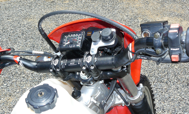
Also added was the Sequoia Adventure Rack
set up from Turbo City (www.turbocity.com/default.php?cPath=69_74&osCsid=5bc794bc4df664874073567063d2ee31) which holds Tour masters Cortech sport saddle bags (www.helmethouse.com). The rack system provides dedicated mounting points for the bags retaining straps and supports them to prevent wear and
damage to the motorcycle. Perfect for use on the CDR because the bags are easily removable for toting into the hotel at trails
end.

After the 40-mile shake down we found a couple
of things to adjust and change (including reducing the side stand length is response to the reduced suspension length) and
the big red Honda is ready for its ride.
TOMORROW A primer on the CDR ride route,
plus a breakdown of the other riders and their bikes.